The Marine Geology and Geophysics Laboratory – SEISLAB – is an operational unit of the Portuguese Institute for the Sea and Atmosphere (IPMA, IP).
Mission
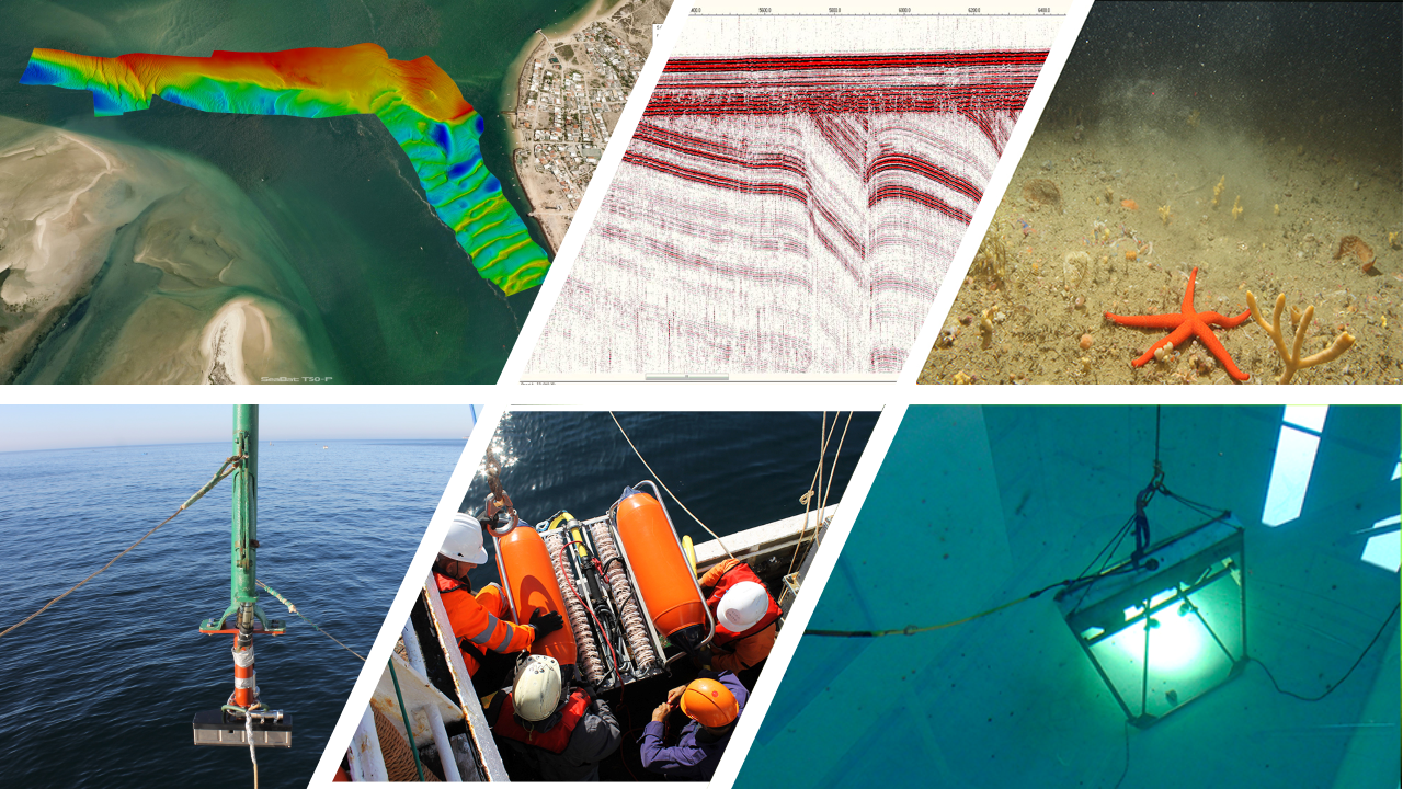
>> Provide the technical capacity for acquisition, processing and interpretation of geophysical and geological data on:
- Seismic reflection
- Bathymetry
- Acoustic backscatter
- Magnetism
- Gravimetry
- Imaging of the seafloor, sub-seafloor, and water column
>> Support the scientific community
>> Contribute to public policy and governance
>> Provide technical and scientific support for undergraduate and postgraduate education programs (BSc, MSc and PhD)
Data curation
>> SEISLAB maintains a WebGIS service based on the GeoNode – the DivGMwebGIS – which provides access to marine geophysics and geology data to the scientific community and the general public.
>> SEISLAB contributes to the IPMA’s platform SOMOSATLÂNTICO / WEAREATLANTIC – the observational ocean research infrastructure that aggregates and provides data and information from IPMA and other entities working in the Atlantic basin.
Scientific drivers
The primary focus of SEISLAB research is to contribute for a comprehensive understanding of the fundamental processes and dynamic interactions that drive the evolution of the ocean seafloor and sub-seafloor.
By studying these complex systems, we aim to uncover the underlying mechanisms that shape the ocean geological evolution over time. Our research is specifically focused on the Portuguese continental shelf, the SW Iberia margin and the deep Atlantic Ocean regions, which have unique geological and environmental characteristics.
The findings from our work have broad applications in various fields, such as assessing natural hazards, reconstructing past environments for scientific analysis, evaluating and managing ocean resources, monitoring environmental changes, assessing ore and mineral resources, contributing to effective ocean governance and policy decisions, and supporting the development of offshore wind farms.
")
Studying instalation areas of offshore wind farms in the Portuguese continental shelf is particularly important for optimizing their emplacement, minimizing environmental impacts, ensuring sustainable energy production and assuring the protection of the marine ecosystems.
Data acquisition and analysis capacity
Marine geophysical equipment
- Multibeam Echo Sounder (MBES) for high resolution (shallow waters) – Teledyne RESON T50-P
- Position and orientation system – Trimble Applanix POS MV OceanMaster
- Parametric Sub Bottom Profiler (SBP) – Kongsberg TOPAS PS120
- 2D mono/multichannel Ultra High-Resolution Seismic System (UHRS) with sparker acoustic source – Geo Marine Survey Systems
- 1 Geo-source 1000 kJ
- 1 Geo-Spark 200 tip
- 2 Geo-Sense monochannel analogic streamers with 8 elements with 0.3 meters spacing (2.4 meters of active section) with 1 Mini-Trace 2-channel recording system
- 1 Geo-Sense 48-channel analogic streamer with 1-2 meters spacing (69 meters of active section) with 2 Multi-Trace 24-channel recording system
- 4 DGPS antennas for positioning
- 2D multichannel Ultra High-Resolution Seismic System (UHRS) with triple sparker acoustic source – Geo Marine Survey Systems
- 4 x Geo-Spark 2000 kJ
- 3 x Geo-Source 400 tip
- 2 Geo-Sense 96-channel digital streamer with 1-meter spacing (95 meters of active section)
- 1 Multi-Trace 96 channels recording system
- 5 “Dual GNSS Geo Pos” antennas for positioning
- 1 x rack mounted server for operations control
- Gradiometer / 2 magnetometers – Marine Magnetics Synapse with capacity for integration with side scan sonar (operating capacity: 0-1000 meters water depth)
- Side Scan Sonar (SSS) – Edgetech 4205 triple frequency 230 / 540 / 850 kHz, (operating capacity: 0-2000 meters water depth)
- Vibrocorer – OSIL 6m Vibrocorer 48KN (operating capacity 0-600 meters water depth)
- Passive Acoustic Monitoring system (PAM) – Vanishing Point Marine
- Camera system for subaquatic images (photos and video) – STR SeaSpyder (operating capacity: 150 meters water depth)
- Sound Velocity Profiler (SVP) – Teledyne ODOM Digibar S (operating capacity: 0-500 meters water depth)
- Sound Velocity Profiler (SVP) – Valeport rapidPro SVT (operating capacity: 0-2000 meters water depth)
- Mini-CTD – equipment to measure conductivity, temperature, depth, salinity, speed of sound (CTD): SonTek – Xylen CastAway-CTD (operating capacity: 0-100 meters water depth)
- Ultra-Short Baseline System (USBL) – HiPAP 352P-MGC R3 Portable System with 0.01° roll and pitch dynamic accuracy, 0.1° heading accuracy RMS with GNSS aided (operating range: 1 – 5000 meters water depth)
Hardware
- 6 High-end workstations (Data Science Ready), for processing and interpretation of marine geophysics and geology data with dual boot operative system (Windows 11 Pro and Red Hat Linux 8.10)
- 7 High-end workstations for processing and interpretation of marine geophysics with Windows 10 Pro
- 9 High-end mobile workstations (Data Science Ready) for field acquisition and interpretation of marine geophysics and geology data with Windows 11 Pro
- 1 Virtual server with Red Hat Linux 8.10 operative system for processing and interpretation support
- 1 Virtual server with Ubuntu server 20.04 operative system for WebGIS services support
- 2 Network Attached Storage (NAS) for data repository (capacity of 0.6 PB with HDD disks)
- 1 Network Attached Storage (NAS) for data processing support (capacity of 56 TB with SDD disks)
- 2 portable Network Attached Storage (NAS) for field data storage (capacity of 15 TB with SDD disks)
Software
> Landmark Suite (6 academic licenses)
> S&P Kingdom (6 academic licenses)
> S&P Kingdom Wind (1 commercial license)
> S&P Kingdom Wind Energy NET (1 commercial license)
> RadExPro (2 commercial licenses)
> Petrel (8 academic licenses)
> Techlog (8 academic licenses)

> Techlog (3 academic licenses)

> Qimera 2 (1 commercial license)
> Qinsy 9 Offshore (1 commercial license)

> Fledermaus 8 (1 commercial license)
> FMGeocoder (standalone) (2 commercial licenses)
> Teledyne PDS (1 commercial license)

> GlobalMapper Pro (2 commercial licenses)
> SonarWiz Office (1 commercial license)
> Matlab (1 commercial license)
> Oasis montaj (2 commercial licenses)
Academic teaching
On-site teaching
SEISLAB provides support to teaching on Marine Geology and Geophysics, particularly to FCUL (Faculty of Sciences of Lisbon University).
At SEISLAB, students gain hands-on experience with marine geophysical methods, with focus on seismic reflection data, working with state-of-the-art interpretation and processing softwares.
>> BSc. course: Marine Geology (practical classes)
>> MSc. course: Sedimentary Basins Dynamics (practical classes)
MSc Thesis support (since 2021)
- Bárbara Martins. Geophysics, Faculdade de Ciências da Universidade de Lisboa. Integrated model of the upper crust and sedimentary cover on the Madeira-Tore Rise based on marine geophysical data. Ongoing
- Duarte da Silva Pereira. Geophysics, Faculdade de Ciências da Universidade de Lisboa. Mapeamento de depósitos de transporte de massa submarinos na costa oeste Portuguesa a partir de dados de reflexão sísmica 2D e 3D. Ongoing
- Telma Godinho (2025). Geology, Faculdade de Ciências da Universidade de Lisboa. Seismic interpretation of 3D seismic data and seismic attribute analysis for the characterization of subsurface geology.
- Inês Janeiro (2025). Ciências Geofísicas, Faculdade de Ciências da Universidade de Lisboa. Utilização de Atributos Sísmicos em Sísmica 3D para
Caracterização da Neotectónica e da Exalação, Acumulação e Armazenamento de Fluidos. - João Magrito (2025). Geology, Faculdade de Ciências da Universidade de Lisboa. Magmatic flow and structural control in dikes of the West Iberia Late Cretaceous Alkaline Province between Cabo Raso and Oeiras based on field work and marine magnetic data.
- Denise Agostinho (2025). Geophysics, Faculdade de Ciências da Universidade de Lisboa. Processamento e Interpretação de Sísmica de Reflexão de Ultra-Alta Resolução da Plataforma Continental Portuguesa.
- Mariana Luís. Engenharia Geológica, Universidade de Évora. Sedimentação Quaternária na Plataforma Continental a Sul de Sines. Ongoing
- Silvia Foiada (2025). Geophysics, Faculdade de Ciências da Universidade de Lisboa. The seismic structure of the NW Moroccan margin, from new high-quality multichannel seismic reflection data.
- David Salvador (2024). Geology, Faculdade de Ciências da Universidade de Lisboa. Geology and constitution of Fe-Mn nodules and crusts in the Lion Seamount of the Madeira-Tore Rise: implications for biomineralization.
- Joana Amaral (2024). Geology, Faculdade de Ciências da Universidade de Lisboa. Evolução ambiental ao largo das ilhas-barreira de Faro-Tavira durante o Pliocénico e Quaternário com base em sísmica de reflexão marinha de muito alta resolução.
- Gabriela Camargo (2022). Geophysics, Faculdade de Ciências da Universidade de Lisboa. Magnetic and gravimetric modeling the Monchique magmatic intrusion in south Portugal.
- Mariana Silva (2021). Universidade de Lisboa. Faculdade de Ciências. Ultra-high resolution seismostratigraphic study of a beach nourishment loan area: Barra-Mira (Northwest Portugal).
- Paloma Simões. Geology, Faculdade de Ciências da Universidade de Lisboa. Tectono-stratigraphic model of the region of the submarine volcano Fontanelas, Estremadura Spur. Ongoing
PhD thesis support (since 2021)
- João Noiva. Universidade de Évora, Escola de Ciências e Tecnologia, Departamento de Geociências. Soerguimento da margem continental do Alentejo no Plio-Quaternário: implicações neotectónicas e potencial em recursos minerais. Ongoing
- Débora Duarte (2022). Royal Holloway University of London. The role of tectonics and diapirism on the evolution of the Gulf of Cadiz contourite depositional system and its significance for the Paleoclimate reconstructions.
- Alessandro Righetti (2022). Universidade de Lisboa, Instituto Dom Luiz. Origin and evolution of the Iberia continental shelf.
- Manuel Teixeira (2021). Universidade de Lisboa, Instituto Dom Luiz. Mass movement processes in the Southwest Portuguese Continental Margin during the Late Pleistocene-Holocene: a multidisciplinary approach for volume quantification, estimation of recurrence times and hazard implications. 2021
- Yaqing Li (2021). Department of Marine Sciences, Zhejiang University (China). Comparison of South China Sea and SW Iberia Continent-Ocean Transition Zone.
Publications
ISI Publications (since 2021)
- Prada, M., C. R. Ranero, I. Grevemeyer, L. Gómez de la Peña, E. Jiménez‐Tejero, M. Neres, A. Ugalde (2025). Crustal structure of the J magnetic anomaly at 31 N, northern Central Atlantic. Journal of Geophysical Research: Solid Earth, 130(12), e2024JB030874. https://doi.org/10.1029/2024JB030874
- Almeida, J., H. Mohammadigheymasi, M. Neres, S. Dumont (2025). Numerical modelling of lithosphere-asthenosphere interaction and intraplate deformation in the Gulf of Guinea. Tectonophysics, 895, 230581. https://doi.org/10.1016/j.tecto.2024.230581
- Neres, M., G. Camargo, A. Soares, S. Custódio, M. Bos, D. Vales, P. Terrinha (2024). Monchique alkaline magmatic intrusion (SW Iberia): geophysical modeling and relationship with active seismicity and hydrothermalism. Tectonophysics, 888, 230426. https://doi.org/10.1016/j.tecto.2024.230426
- Duarte, D., Magalhães, V.H., Hernández-Molina, F.J., Roque, C., Menapace, W., 2024. Interaction between active tectonics, bottom-currents processes and coral mounds: a unique example in the NW Moroccan Margin, Southern Gulf of Cadiz. Deep Sea Research Part I: Oceanographic Research Papers, 104330. https://doi.org/10.1016/j.dsr.2024.104330. https://doi.org/10.1016/j.dsr.2024.104330
- Roque, C., Hernández-Molina, J., Brito, P., Madureira, P., Quartau, R., Magalhães, V. and Carrara, G., 2023. Contourite depositional systems offshore Madeira Island: Decoding the deepwater circulation since the late cretaceous to the Quaternary in the NE-Central Atlantic. Global and Planetary Change: 104118. https://doi.org/10.1016/j.gloplacha.2023.104118
- Neres, M., & Ranero, C.R. (2023). An appraisal using magnetic data of the continent-to-ocean transition structure west of Iberia. Geophysical Journal International, 234(3), 1819-1834. https://doi.org/10.1093/gji/ggad163
- Neres, M., P. Terrinha, J. Noiva, P. Brito, M. Rosa, L. Batista, C. Ribeiro (2023). New Late Cretaceous and CAMP magmatic sources off West Iberia, from high-resolution magnetic surveys on the continental shelf. Tectonics, 42(7). https://doi.org/10.1029/2022TC007637
- Pereira, A., Azevedo, L., Soares, A. (2023). Updating Local Anisotropies with Template Matching during Geostatistical Seismic Inversion. Mathematical Geosciences, 55:497–519. https://doi.org/10.1007/s11004-023-10051-3
- Grevemeyer, I., C.R. Ranero, V. Sallarès, R. Bartolomé, L. Batista, M. Neres (2022). The continent to ocean transition in the Iberia Abyssal Plain. Geology. https://doi.org/10.1130/G49753.1
- Ramalho, M., L. Matias, M. Neres, M.M.C. Carafa, A. Carvalho, P. Teves-Costa (2022). A sanity check for earthquake recurrence models used in PSHA of slowly deforming regions: the case of SW Iberia. Natural Hazards and Earth System Sciences, 22(1), 117-138. https://doi.org/10.5194/nhess-2020-300
- Duarte, D., Roque, C., Ng, Z.L., Hernández-Molina, F.J., Magalhães, V.H., Silva, S., Llave, E., 2022. Structural control and tectono-sedimentary evolution of the Gulf of Cadiz, SW Iberia since the late Miocene: Implications for contourite depositional system. Marine Geology 449, 106818. https://doi.org/10.1016/j.margeo.2022.106818
- Batista, L., C. Hübscher, P. Terrinha, L. Matias, A. Afilhado, A. Loureiro, and B. Weiß (2022). Crustal structure across the São Miguel Island (Azores, North Atlantic) and tectonic implications. Marine Geophysical Research, 43(4), 41. https://doi.org/10.1007/s11001-022-09503-y
- Gamboa, D., Omira, R., & Pedro Terrinha. Spatial and morphometric relationships of submarine landslides offshore west and southwest Iberia. Landslides. https://doi.org/10.1007/s10346-021-01786-3
- Terrinha, P., T. Medialdea, L. Batista, L. Somoza, V. Magalhães, F.J. González, J. Noiva, A. Lobato, M. Rosa, E. Marino, P. Brito, M. Neres, C. Ribeiro (2022). Integrated thematic geological mapping of the Atlantic Margin of Iberia. Geological Society of London, Special Publications, 505(1), 97-115. https://doi.org/10.1144/SP505-2019-90
- Mil-Homens, M., P. Brito, V. Magalhães, M. Rosa, M. Neres, M. Silva, E. Salgueiro, T. Drago, A.I. Rodrigues, M. Guerra, M.J. Gaudêncio, E. Almeida, A. Silva, M. Freitas, C.A. Pinto, P. Terrinha (2022). Integrated geophysical and sedimentological datasets for assessment of Offshore Borrow Areas: The CHIMERA project (Western Portuguese Coast). Geological Society of London, Special Publications, 505(1), 131-153. https://doi.org/10.1144/SP505-2019-100
- Gamboa, Davide, Rachid Omira & Pedro Terrinha. A database of submarine landslides offshore West and Southwest Iberia (2021). Scientific Data. https://doi.org/10.1038/s41597-021-00969-w
- Gamboa, D., R. Omira, A. Piedade, P. Terrinha, C. Roque, N, Zitellini (2021). Destructive episodes and morphological rejuvenation during the lifecycles of tectonically active seamounts: Insights from the Gorringe Bank in the NE Atlantic. Earth and Planetary Science Letters. https://doi.org/10.1016/j.epsl.2021.116772
- Civiero, C., S. Custódio, M. Neres, D. Schlaphorst, J. Mata, G. Silveira (2021). The role of the seismically slow Central-East Atlantic Anomaly in the genesis of the Canary and Madeira volcanic provinces. Geophysical Research Letters, 48. https://doi.org/10.1029/2021GL092874
National publications (since 2021)
- Gamboa, D., M. Neres, P. Terrinha, P. Brito, J. Noiva (2022). O Impacto dos Dados de Exploração Petrolífera no Avanço do Conhecimento Científico das Margens Continentais e no Estudo dos Riscos Geológicos em Portugal. In: Boletim de Minas, 55 – Petróleo – Prospeção e Pesquisa em Portugal – 2020-2021. Edited by Direção-Geral de Energia e Geologia. ISSN: 00008-5935
- Pacheco, A., Luís, M., Nogueira, P., Magalhães, V., Noiva, J., Velez, S., Moita, P., Tsoupras, A., Terrinha, P., Ribeiro, C., 2021. Caracterização da Cobertura Sedimentar da Plataforma Continental Alentejana. Characterization of the Alentejo Continental Shelf sedimentary cover. Geonovas 33.
Main projects (since 2019)
CHIMERA Norte
PA nº 086/2024.1 (APA)
2025-2026
Geological, geophysical and geotechnical characterization of the sedimentary record of borrow areas for beach nourishment. Service contracted by the Portuguese Agency for the Environment (APA)
EMODnet – European Marine Observation and Data Network
Grant agreement n. 101094227 (EU)
48 months
Network of organisations supported by the EU’s integrated maritime policy. These organisations work together to observe the sea, process the data according to international standards and make that information freely available as interoperable data layers and data products.
GSEU – Geological Service for Europe
Grant agreement n. 101094227 (EU)
60 months
Bringing the Subsurface into the Light – drawing together the baseline data and knowledge needed to manage Europe’s natural resources and reach Net Zero.
OWF Studies – Technical studies for offshore energy potential
RP-C21- i07.01 (PRR)
2023-2026
Provide detailed relevant data on the morphology, geology, geophysics and geotechnical properties of the seafloor in order to inform Offshore WindFarms (OWF) developers towards engineering and financial strategies. Provide relevant data for the definition of environmental status and baseline.
AMPO – Monitorização de Áreas Marinhas Protegidas Oceânicas
Fundo Azul
Ecology of the Madeira-Tore Geological Complex and adjacent Seamounts. Characterization of oceanic areas with significant ecological value, identifying key sites for conservation and providing scientific support for the planning and management of current and future Marine Protected Areas.
TRIDENT – Technology based impact assessment tool foR sustaInable, transparent Deep sEa miNing exploraTion and exploitation
Grant agreement n. 101091959 (EU)
2023-2027
Develop a monitoring and inspection system for environmental impact assessment of deep-sea exploration and future exploitation activities. Identify and measure all relevant physical, chemical, geological and biological parameters at the sea surface, mid-water and on the ocean floor.
LISA – Lithospheric structure of the Southwest Iberia Margin
PTDC/CTA-GEF/1666/2020 (FCT)
2020-2024
Acquire new high-quality geophysical data in underexplored regions of the SW Iberia margin and contribute to a new assessment of its lithospheric structure, nature of domains, and geodynamic evolution
RESTLESS – IntegRated tools to decipher the genesis and spatio-temporal evolution of seismic sequences
PTDC/CTA-GEF/6674/2020 (FCT)
2020-2025
Integrate cross-disciplinary high-resolution observations of the spatio-temporal evolution of: 1) seismic activity, 2) Earth structure at depth, 3) crustal fluids, and 4) sensitivity to external forcings, in order to quantify the state-of-activity of geologically active systems.
TAGUSGAS
PTDC/CTA-GEO/031885/2017 (FCT)
2018-2021
Tsunami hazard assessment of the Lisbon city associated to the Tagus delta landslide revealed by reflection seismic data.
ATLAS – Advanced Tri-axis Lightweight Aeromagnetic System
PTDC/CTA-GEF/31272/2017 (FCT)
2018-2021
Operation of triaxial drone-borne aeromagnetic magnetometer and application to geological studies.
MINEPLAT
ALT20-03-0145-FEDER-000013
2016-2019
Evaluation of the potential of mineral resources on the Alentejo (southwest Portugal) continental shelf and the natural constraints imposed by the Plio-Quaternary margin uplift
