Workflow
Environmental Studies are organized into six interplaying work packages WP1, WP2, WP3, WP4, WP5, WP6:
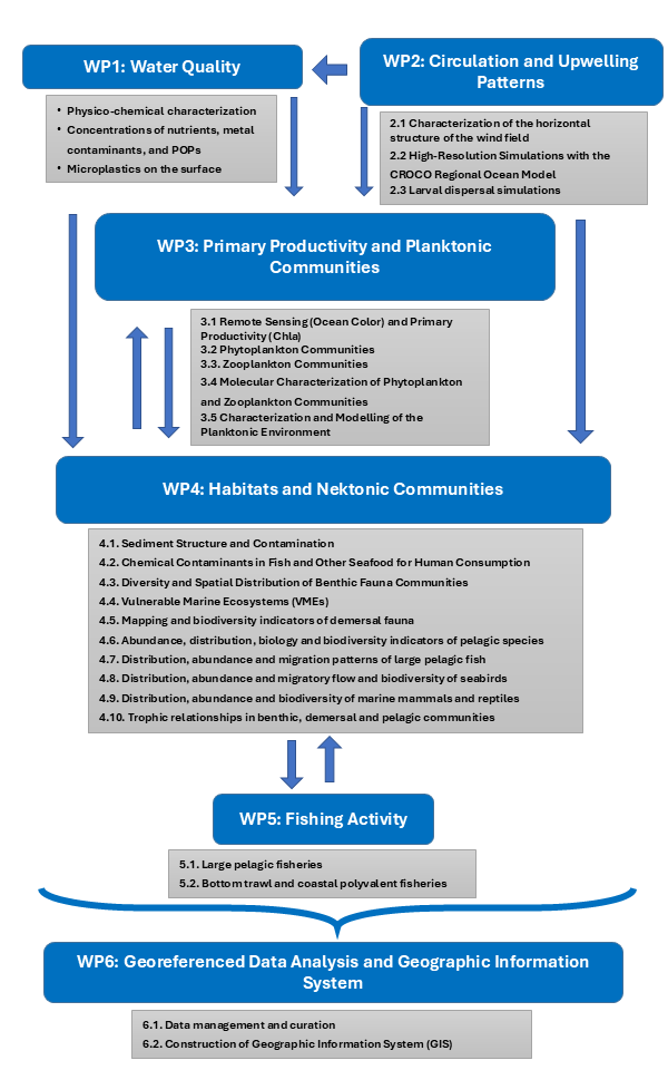
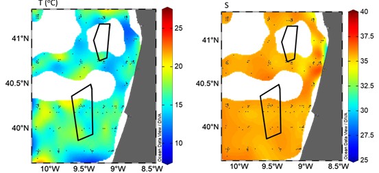
Water quality (WP1)
>> Location: PAER and surrounding areas (Figueira da Foz and Leixões)
Aims:
- Assessment of the chemical oceanographic characteristics of the water column.
Datasets:
Historical oceanography data:
- Temperature
- Salinity
- O2
- pH
- PO4
- SiO2
- NO3
- NO3+NO2
- NH4
- Chlorophyll-a
Data sources:
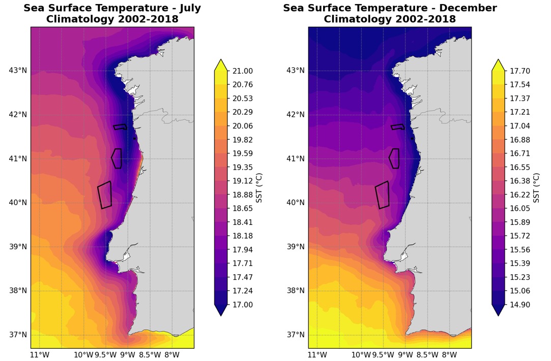
Upwelling and current patterns (WP2)
>> Location: Portuguese continental coast, with focus on PAER areas
Aims:
- Characterize the spatial structure and temporal variability of the wind field and its rotational
- Characterize the surface currents and circulation, local upwelling/downwelling, temperature, and salinity patterns
- Identification of mesoscale stationary structures
Datasets and Methods
- European ReAnalysis ERA5 and simulations with the regional atmospheric model Weather Research and Forecasting Model (WRF), used to characterize the wind patterns
- Simulation with the CROCO regional ocean model (IBv2.0 configuration) between 2002 and 2018, forced by atmospheric forcings from the base simulation performed with the WRF atmospheric model, used to characterize oceanographic parameters
Primary productivity and planktonic communities (WP3)
>> Location: Portuguese continental coast, with focus on PAER areas
Aims:
- Characterize the temporal variability and spatial distribution of phytoplankton biomass
- Characterize the mesozooplankton community and quantify its relative abundance
- Characterize the biodiversity, abundance, and biomass of planktonic communities using biophysical models
Datasets and Methods
- Daily remote sensing maps of ocean colour, using data from Ocean Colour Climate Change Initiative (OC-CCI; V6 1km 2003–2022)
- Samples from previous campaigns (PT-DEPM19-HOM and PT-DEPM22-HOM) collected in the study areas were used for:
- Characterize the mesozooplankton community with FlowCam
- DNA extraction, high-throughput sequencing (metabarcoding), bioinformatic processing
- Lagrangian dispersal simulations were conducted using a compilation of basic biological data from diverse literature sources as input
Habitats and nektonic communities (WP4)
>> Location: Portuguese continental coast, with focus on PAER areas
Aims:
- Characterize the ecological communities, focusing on:
- Benthic fauna
- Demersal and pelagic fish
- Large pelagic migrant species
- Seabirds, marine mammals, and reptile communities
- Compile available information on Vulnerable Marine Ecosystems (VME)
- Characterize the food web of the Portuguese continental shelf, analysing the isotopic composition (δ15N and δ13C) of the most abundant or relevant organisms in the food chain
Datasets:
- Data/samples from oceanographic surveys (PNAB/DCF CRUSTACEOS, DEMERSAL, PELAGO), including historical data
- Historical data from seabird census (European Seabirds At Sea, Seabird and Marine Monitoring Network, and during PELAGO campaigns)
- Georeferenced data available for the region of interest
- Electronic logbooks and data from on-board observers for surface longlines
- Documentation and other resources from various sources (e.g., DGRM, IH, EMODNET).
Methods:
- Biodiversity indices
- Data modelling
- Isotope analysis using continuous flow isotope mass spectrometry
Fishing activity (WP5)
>> Location: Portuguese continental coast, with focus on PAER areas
Aims:
- Spatial assessment of fishing intensity, catch and revenue
- Quantify potential fishing-related changes in future exclusion zones
Datasets and Methods:
- Compilation of historical logbook data, IPMA observer data, and first sale fish auction values data for commercial fishing off the Portuguese coast
- Estimation of overlap of the fisheries with the offshore wind areas based on fishing effort and catches
Data integration on the SOMOSATLÂNTICO platform (WP6)
Aims:
- Ingestion and storage of data from the environmental characterization study on the SOMOSATLÂNTICO platform
- Construction of a GIS dedicated to the project
- Development of spatio-temporal models for the description, synthesis, and prediction of environmental variables.
Datasets and Methods:
- Data collected in all tasks
- Processment and standardization of data
- Development of open-source Python scripts and creation of metadata in accordance with the INSPIRE Directive
Partners